
")
Length: 4 km and 610 meters.
Duration: 1 hour and 35 minutes.
Descent: 419 meters.
Route Rating: Cross and return on the same path.
Reccommended: In all mountaineering clubs in the country, as well as those with some mountaineering experience.
Season: All year around, provided there are no snowfalls.
* The information listed above is just to go.
The trail is part of the international path E6 which starts from the village of Livaditi and, crossing a beautiful beech forest filled with streams of running water, it leads to the waterfall of Livaditis.
General Information:
It is a path of total length 4 km and 610 meters and more specifically 3 km and 410 meters path and 1 km and 200 meters on asphalt with 315 altitudinal gradient meters. The duration is 1 hour and 35 minutes. Along the trail there no road signs as well as no signal for some of the phone companies. Generally, it is classified as a medium difficulty route and can be performed by children aged over 10 years.
USEFUL PHONE NUMBERS:
European Emergency Number: 112
Fire Brigade: 199
E.K.A.V. (Ambulance Help): 166
Health Center of Stavroupoli: +30 25423 50000
All the above are summarized in the following chart:
Click on the word "Wikiloc" so you can store the route on a Garmin gps device or Androit or Smartphone device. You can also print the information without the illustrations shown below. The tracking of the trail was done using a 650t Montana gps device by Garmin
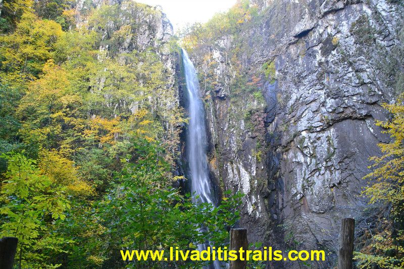
Here you can have a first look at he waterfall: Waterfall of Livaditis
In Particular:
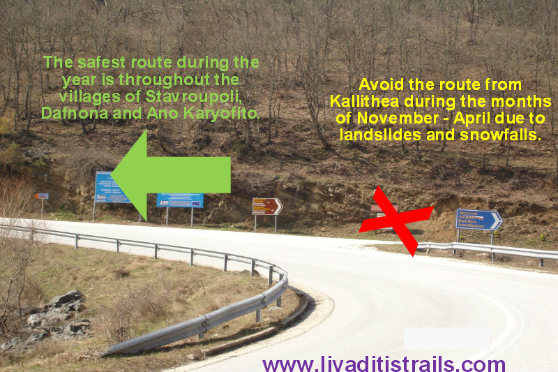
Starting from the city of Xanthi, you could follow the road to the small town of Stavroupoli and then after passing the villages of Dafnona and Ano Karyofito you end up, after a distance of 48 km in the mountain village of Livaditi at an altitude of 1.250 meters. While you are on your way to Stavroupoli and more specifically at the height of Lykodromio at an altitude of 285 meters, you will notice that there is a right junction, which ends up in the village of Livaditi through Kallithea. It is advisable to avoid this route during the months of November to April, because due to frequent snowfalls the route closes and it is difficult to get to your destination (this road is of minor importance and during the winter season snow removal equipment is not available). Also, there is no telephone signal all the way, just on a few points. This particular route is far more pleasant to be followed during the other months, from May to October.
Livaditis is the highest mountain village of Xanthi with only 8 residents. If you wish, you could leave your car in the village of Livaditi, otherwise there is place to leave it at the place where the path starts.
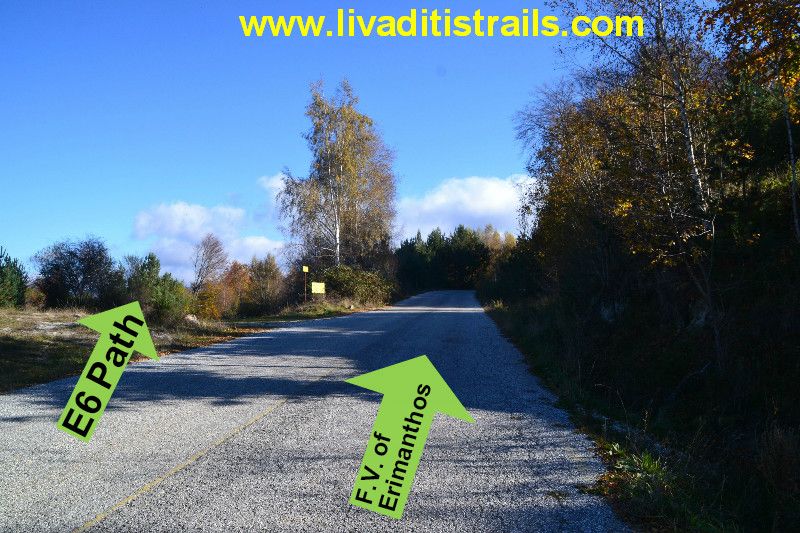
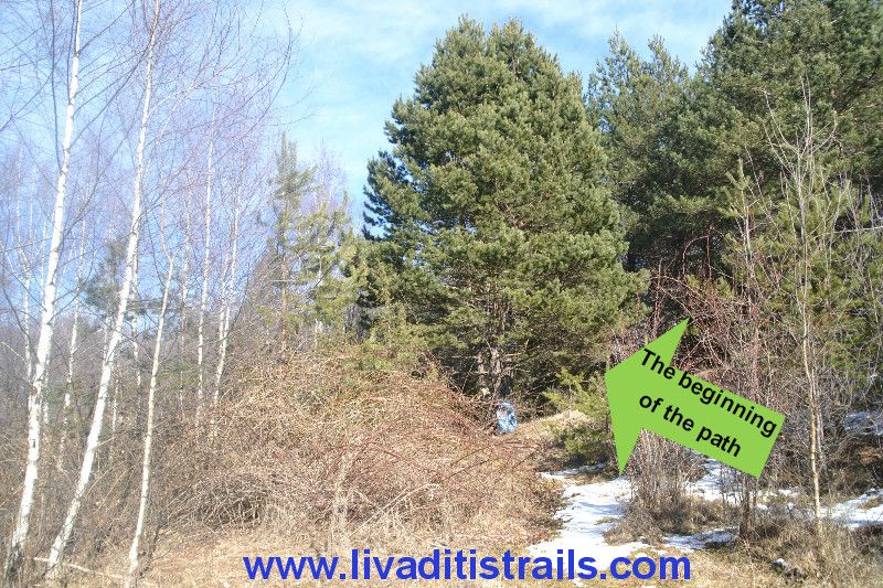
You follow the asphalt driveway that goes to F.V. of Erimanthos for 1 km and 200 meters. On your left, you will see a small yellow sign, which says "No Hunting" and you will find that there is a small vacant lot (at an altitude of 1.205 meters).
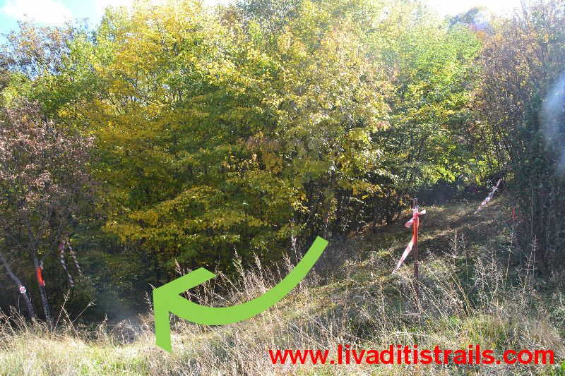
Far right into the vacant lot, you will find a tree with a red cloth and a red and white sign. The 3 km long and 410 meters trail with a duration of 1 hour and 20 minutes is very relaxed walking and is also very well signposted. However, you must follow the specific red and white signs or the red clothes, so as not to get lost (do not follow the orange signs or the phosphorescent red cardboards on the trees because you will reach Trahoni, in Drama).
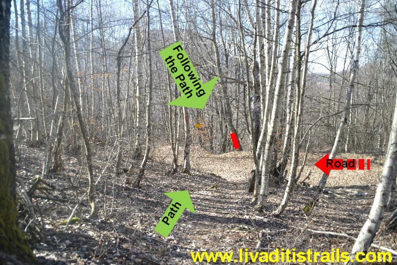
You therefore start walking and at the first 10 minutes that you have already covered the first 585 meters of the trail, you will see that it meets with a rural road (at an altitude of 1.210 meters). You cross it vertically and just opposite there is a yellow sign that shows you where the trail continues.
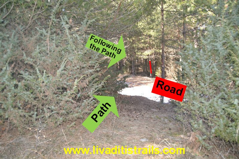
After 5 minutes or 255 meters away (840 meters since the start of the path), you will meet for the second time the same country road (at an altitude of 1.185 meters) and you follow again the same procedure. There is a yellow small sign and a red sign in a tree that informs you on how to find the path again. You will just have to be careful because the slope at the beginning is a bit steep.
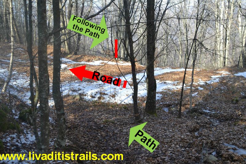
After another 15 minutes of walking or 640 meters further (1.480 meters from the start) and at an altitude of 1.085 meters you will find for the third and last time the same rural road and you will continue with the same procedure. There are small yellow signs and a red sign in a tree that inform you on how to find your path again. As mentioned before, you will have to be careful because the slope at the beginning is a bit sleep. This rural road was constructed for logging purposes and if you get fooled and follow it on your way to the waterfall, you might get confused and you will not reach your destination.
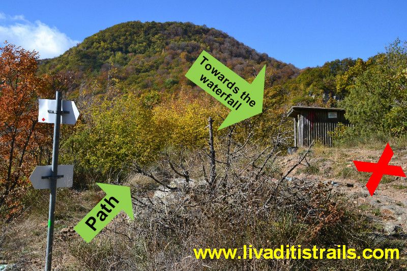
You then follow the signs and the red cloths that there on the rocks and trees for another 380 meters (1.860 meters from the beginning) or a ten minute walk, until you find a glade and on your right there is an iron pole with a red cloth, at an altitude of 1.010 meters.
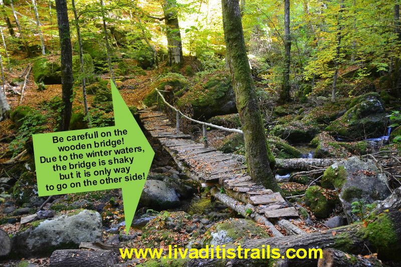
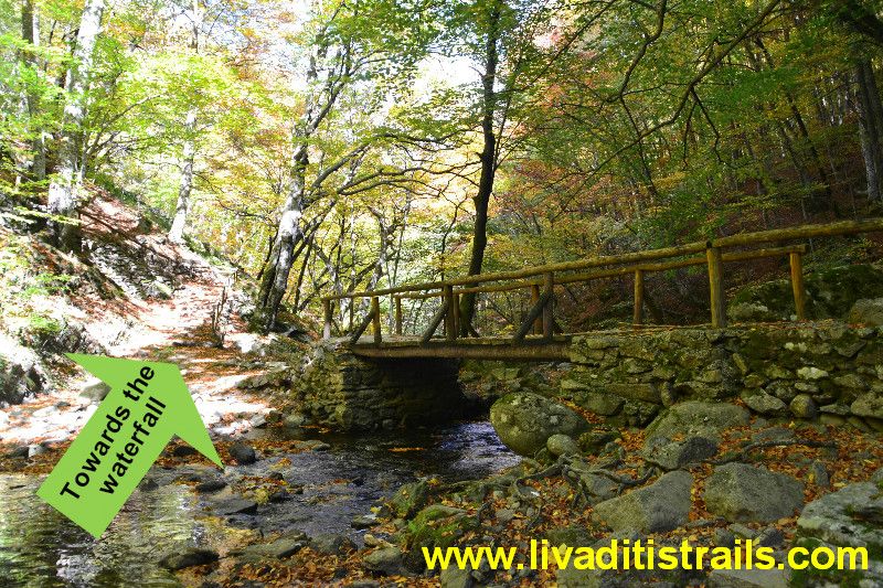
For the next 10 minutes you get off all right down for another 300 meters (2.160 meters from the beginning) until you come across a wooden bridge at an altitude of 970 meters. You cross and go towards it.
For the next 10 minutes or 280 meters (2.440 meters from the beginning) the route is uphill until you meet a wooden house at an altitude of 1.010 meters. In the last few meters, the path meets the "short path" that comes from the "parking" area. The last 970 meters, in other words, are common to both paths. When you reach this intersection, continue your downward route until you meet and pass the wooden house first of all where you continue to descend.
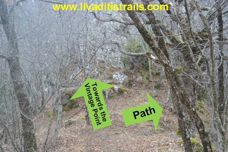
After walking 100 meters (after the wooden house), you will meet a rock next to which an uphill footpath starts for a few meters and leads you to a nice view point (990 meters altitude).
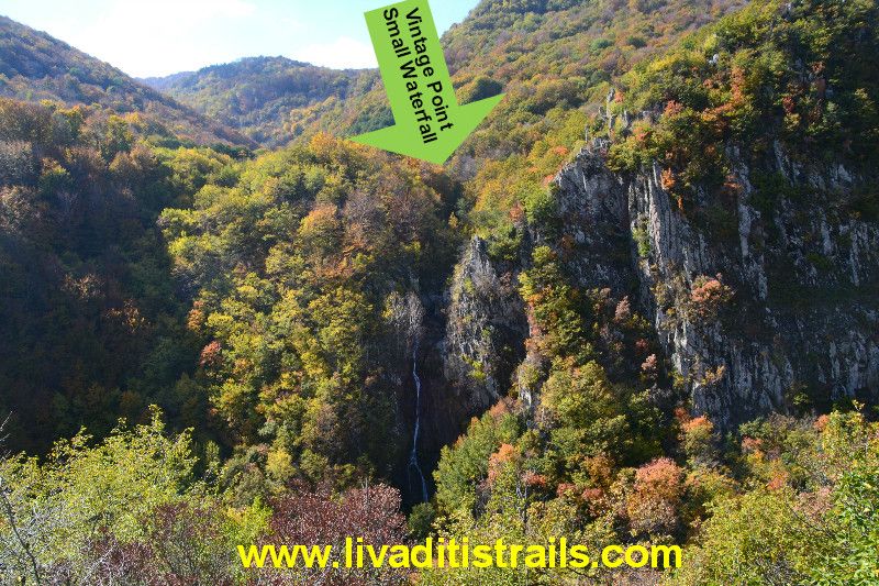
From there you can admire a smaller waterfall, whose water comes from the streams of Livaditi and a little further from there that "pops", it meets with the waters from the streams of "Stravorema", thus forming an impressive spectacle that the big waterfall gives. Also behind you, you can look at the tops of the mountains belonging to the country of Drama.
You return to the path and continue your downward route for another 15 minutes. You will start to feel close to your destination when you meet a wooden bridge (altitude 865 meters), many springs and the church of S. George which was built in memory of Tilemachos Samouridi, one of the first people who walk the path to the waterfall, since the mid-1980s.
There are 60 meters (5 minutes) of uphill walking remaining until you reach the vintage point from where you can admire the waterfall, at an altitude of 885 meters. Please be aware that the waterfall has a height of 40 meters and it is the largest in the Balkans in terms of quantity and volume of running water.
No matter how many photos you will take and how many hours you will sit to enjoy the waterfall, it is never enough to satisfy your senses. Every time, the sight of it offers different emotions and thoughts.
When you have sated this unique spectacle, it is time to come back. You should keep in mind this:
- You should not worry about the uphill way back, because you descend slowly and you will follow approximately the same rate as you go up the hill. If you keep the time needed to descend the slope, calculate a quarter more for the uphill way back, because you will need a few stops.
All along the trail you feel that you are in the heart of Nature and that you can breathe and be a part of her... Every step is a breathe of new life... If anything else, it will be a wonderful experience for you and your company!!!
The passage of the trail occured on Sunday 22th of February 2015, the same day we gathered all the information that was mentioned, as well as the photographs included in the narrative of the path. We consider ourselves responsible, so we would like to treat those who love Nature and hiking and enjoy learning about new places with the same responsibility. We would also like, if you cross the trail above or any other on our website, to contact us (email: This email address is being protected from spambots. You need JavaScript enabled to view it.) whether we were accurate on our description or there was a flaw that should be corrected.
Thank you for your trust and for visiting our website.
The translation in English was made by "Fytopoulou Sofia" and we thank her, for her help.