")
Route length: 13,8 km.
Duration: 4 hours.
Altitudinal slope: Ascent: 597 meters Descent: 220 meters.
Route description: Ascent-Medium difficulty.
Recommended to: All mountaineering clubs, as well as individuals with certain experience in mountain trails.
Season: All year around, on condition that there is no snow.
* The information above is given to reach your destination.
A stunning route that will lead you to one of the highest summit of the district and will amaze you with its beauty, any time of year you decide to cross it. Besides, a trail through the mountains of Rhodope was never indifferent to anyone.
Information:
It is a route of 13 km and 800 meters total length - more specifically a 10 km and 300 meters of path, 3 km and 500 meters of country road with altitudinal slope of 597 meters and a 220 meters descent. The duration of the trail is about 4 hours. At the beginning of the path (after the kiosk) you can notice marks of the “Rodopi Ultra Trail” marathon on the trees, as well as the red signs. Through the path there is no mobile service, except on the hilltops. In general, it is described as a route of medium difficulty, due to its long distance.
USEFUL PHONE NUMBERS:
- European emergency number: 112
- Fire Brigade: 199
- E.K.A.V. : 166 (Ambulance Help)
- Health Centre of Stavroupoli: 25423-50000
All the above are summarized in the following chart:
Click on the word "Wikiloc" so you can store the route on a Garmin gps device or Androit or Smartphone device. You can also print the information without the illustrations shown below. The tracking of the trail was done using a 650t Montana gps device by Garmin
The translation in English was made by " Sidiropoulou Athina " and we thank her, for her help.
In particular:
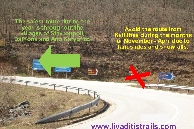
Starting from the city of Xanthi, which is located in the North - Eastern Greece you could follow the road to the small town of Stavroupoli and then after passing the villages of Dafnona and Ano Karyofito you end up, after a distance of 48 km in the mountain village of Livaditi at an altitude of 1,250 meters. While you are on your way to Stavroupoli and more specifically at the height of Lykodromio at an altitude of 285 meters, you will notice that there is a right junction, which ends up in the village of Livaditi through Kallithea. It is advisable to avoid this route during the months of November to April, because due to frequent snowfalls the route closes and it is difficult to get to your destination (this road is of minor importance and during the winter season snow removal equipment is not available). Also, there is no telephone signal all the way, just on a few points. This particular route is far more pleasant to be followed during the other months, from May to October (Picture 1).
 Picture 1.
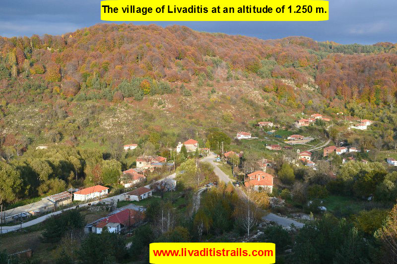
Livaditis is the highest mountain village of Xanthi at an altitude of 1.250 m. with only 8 residents (Picture 2).
 Picture 2.
Just after the settlement of Leivaditis (8km) you arrive at the forest site of Erymanthos (1.315 meters of altitude). At the end of the road you can park your car and start hiking. As you arrive, on your right, you will notice a small chapel and the country road that starts on its right (having at your rear the forest village where you parked your car, you just need to take a look on your right, at the point where the paved road ends, and you will notice both the small chapel and the country road). So, todays adventure starts from the country road (Picture 3).
 Picture 3.
After walking about 700 meters on the country road, at an altitude of 1.365 meters, you will find a crossroad and two trees, on which there are red sings. A little further down you can notice a white building (it is a water tank that provides water to the forest village). You must not follow the path that starts from this point, because it will lead you to Chaintou summit (Picture 4).
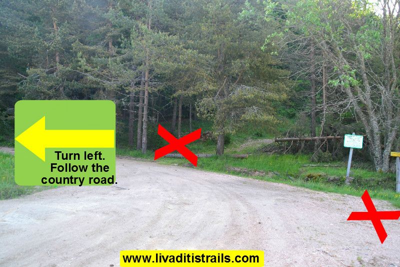 Picture 4.
You continue walking on the country road for another 2 km when you reach a kiosk from which start three dirt roads. You mustn t follow any of them because if you take a closer look just behind the kiosk you will notice the start of the first part of the trail. You will also understand it by the red sings on the trees only a few steps away from the kiosk. So, you have just walked the first 2 km and 700 meters of the path in about 35 minutes and you are at an altitude of 1.400 meters. This is a good warm-up for the difficult route that comes next (Picture 5).
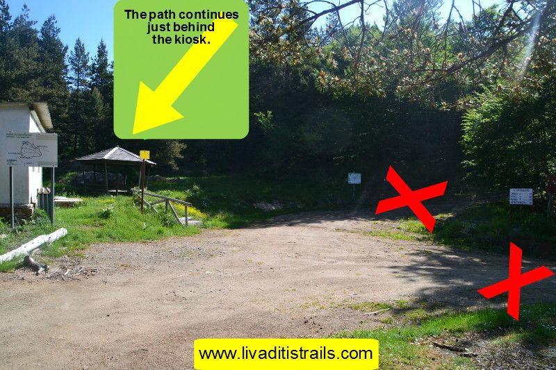 Picture 5.
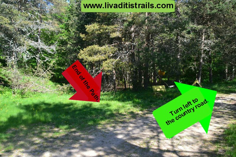
The part of the path that starts behind the kiosk is the first part of the trail, because after 2 km and 40 meters, it will lead you again to the country road in about 35 minutes at an altitude of 1.430 meters Otherwise, you should keep in mind that the starting from the kiosk, the road that points to Gyftokastro (the middle one) will lead you at the same place as the path, although its 1 km and 240 meters longer. It is up to you whether you will choose to walk though it while ascending or descending from the summit and always taking into consideration how tired you may feel (Picture 6).
 Picture 6.
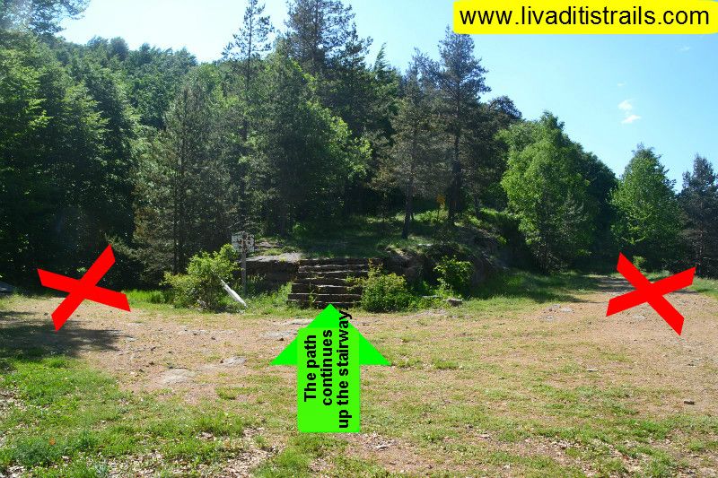
As you get back on the country road, turn left and continue walking for 800 meters until you see a stairway on the hill with two country roads, one on its left and one on its right. You dont follow any of them. You can take a small break for some rest and prepare yourselves to continue up the stairway, from which starts the second and last part of the trail that will lead you to Gyftokastro summit. Up to this point, you have already walked 5 km and 540 meters (3,5 km of country road and 2 km and 40 meters of path) in 1 hour and 25 minutes and from the place where you parked your car at an altitude of 1.315 meters, climbed 160 meters and now you reached an altitude of 1.475 meters (Picture 7).
 Picture 7.
From the very first steps of the path that starts after the stairway, you can easily understand the annoying incline of the path from now on. You are about to ascend for 140 meters of altitude in 1 km that will take you 20 minutes to achieve. The trail is characterised of two slopes, one at the beginning and one at the end. You have already walked over the first slope. The path from now on becomes easier to cross with only a few easy slopes to go over. Right after the slope, you will see a summit. Its not Gyftokastro, but Tsichla. The path doesnt go through this summit (unless of course you want to do a little detour) but over it and right below (Picture 8).
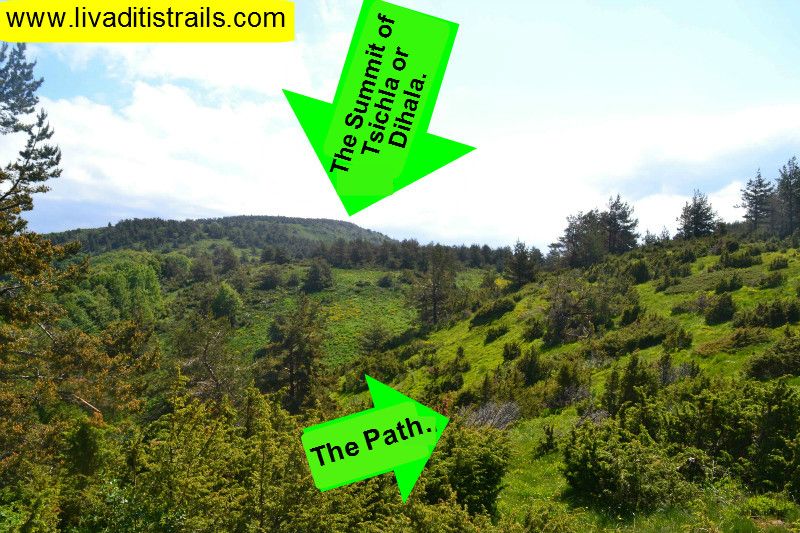 Picture 8.
By the time the ascent ends and until you arrive to the junction to the Tsichla summit, you need to walk another 1 km and 460 meters in 30 minutes and reach an altitude of 1.730 meters. A fallen tree with a marking tape on it shows that you reached the crossroad for the two summits. You continue to walk along the left path and soon seeing red marks on the trees (Picture 9).
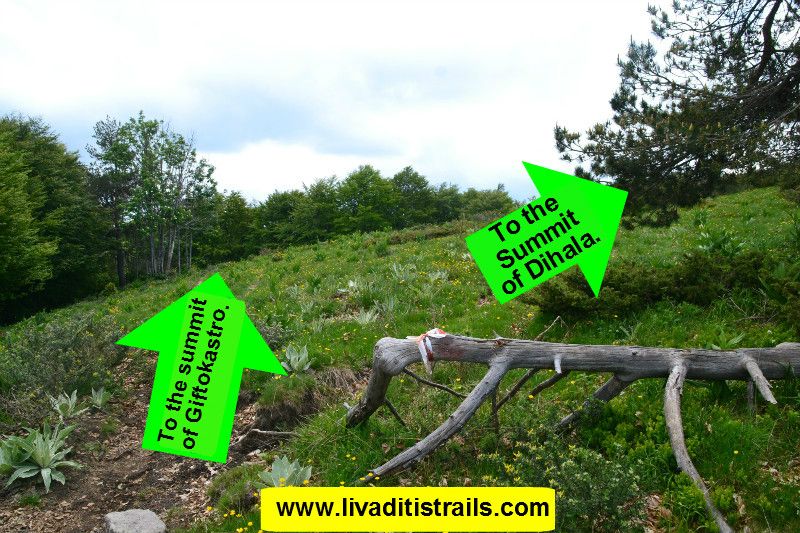 Picture 9.
About 10 minutes after leaving the junction will have your first contact with the summit of Gigtokastro (Picture 10).
 Picture 10.
From the junction of Tsichla summit continue walking on a distinct path for 1 km and 820 meters, about 25 minutes, and you will start getting closer to the boarders with Bulgaria. You will easily understand this by the pyramids, which were used as a distinctive mark of the boarders between the two countries. The pyramids still exist and you will find the first one in a forest path. A small tree on the path is the junction to Giftokastro on your right. Don't turn right, continue straight to the path, in the background you will notice the red sings that show you how the path continues (Picture 11).
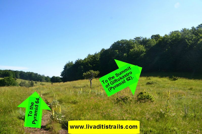 Picture 11.
Walk for another 450 meters and after 5 minutes you will reach pyramid 64 over the Hellenic- Bulgarian boarders (Picture 12).
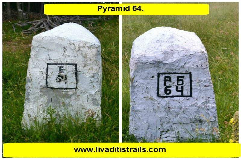 Picture 12.
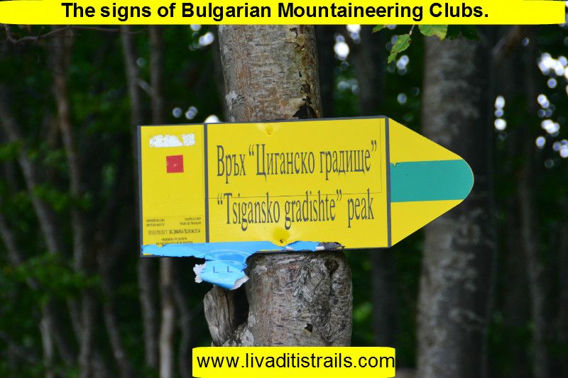
If you take a look at your right, you will notice that the mountain has the same name on the Bulgarian side, too (Picture 13).
 Picture 13.
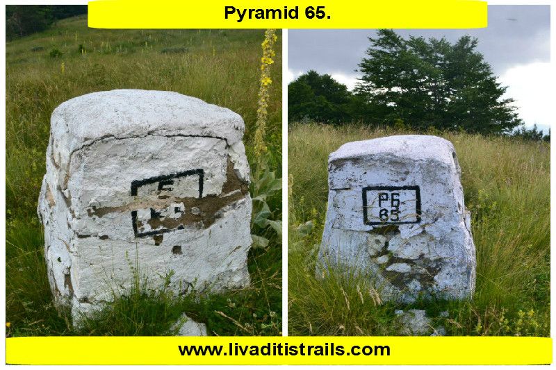
After you pass by pyramid 64, continue walking on the boarder for another 650 meters and in 13 minutes at an altitude of 1.680 meters you will find yourselves at... pyramid 65 of course (Picture 14).
 Picture 14.
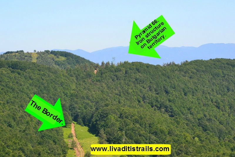
From this pyramid you can see: in front you a small descending valley which goes up again a hill on the other side where you can make out an iron structure on Bulgarian territory (Picture 15).
 Picture 15.
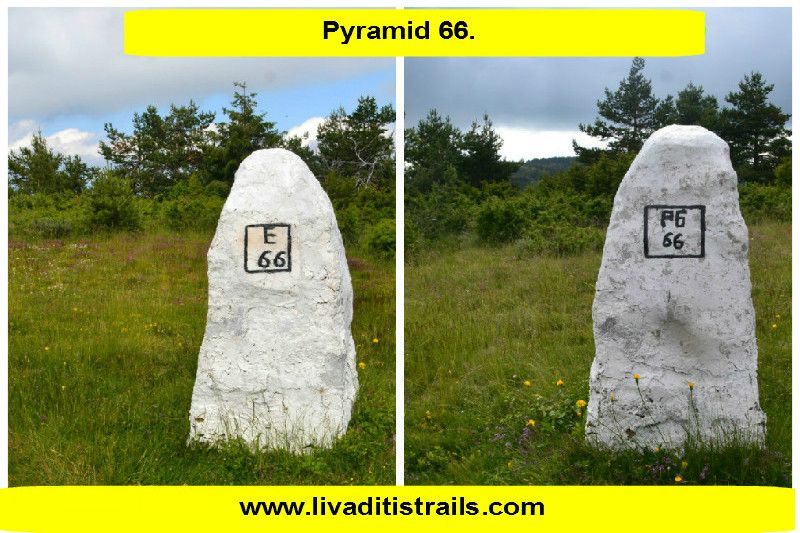
The distance between the two pyramids 65-66 is 1 km and 240 meters and you will need about 25 minutes to complete it. You are now at an altitude of 1.680 meters (Picture 16).
 Picture 16.
Your path is straight and after 300 meters, about 5 minutes you will see on your right a big, green, iron structure that was used as a viewpoint for military purposes and right below it a small kiosk with a bench, where you can have some rest. You need to make a little detour for about 100 meters, but it definitely worth’s it as you don't get to see something like this often (Picture 17).
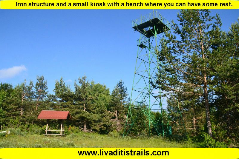 Picture 17.
After a little time of relaxation, you go back the direction you came from. In 100 meters you will find a crossroad with two side roads-paths. The left one leads you to pyramid 66, so you shouldn’t follow it. That’s why you must follow the right one which, after 200 meters, leads you to and old pen which can be used for rest and for sleep (in case your are tired) or as an emergency shelter (Picture 18).
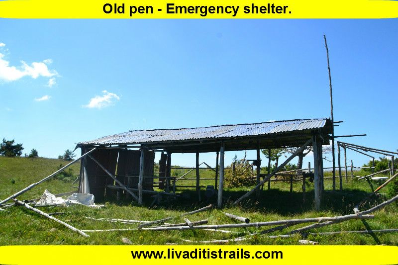 Picture 18.
Continue walking on the same side road- path for another 900 meters. The path is easily noticeable and in good condition. At a certain point, you will realise that the path is interrupted by a small stream that flows down from a hill on your left, at an altitude of 1.625 meters and after 17 minutes of walking (Picture 19).
 Picture 19.
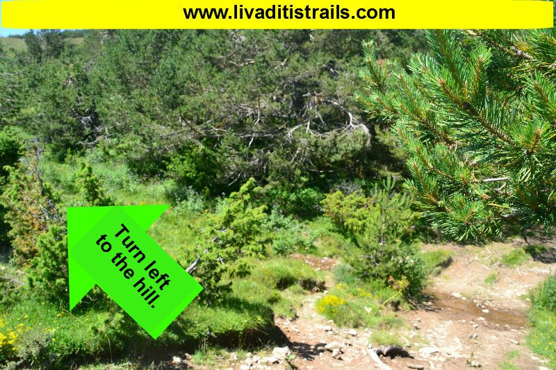
Don't cross the stream, but go up the left hillside until you reach the higher point and then go across to the opposite (right) hillside to continue your path to the top, which is not very far away (Picture 20).
 Picture 20.
From the stream to the top it is estimated that you need about 15 minutes to ascend from 1.625 meters to 1.699 meters. You will walk the last 700 meters of the trail that will reward you with an amazing view and an endless feeling of pleasure which derives from the fact that you have just conquered the third highest summit of Xanthi District, Mallia (Picture 21).
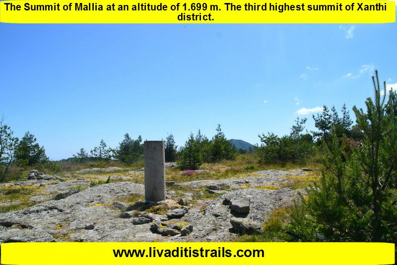 Picture 21.
As the narrative of this beautiful trail comes to an end, we you like to point out a few things. The passage of the trail occurred on Saturday 3th of October 2015 and the same day we gathered all the information that was mentioned, as well as the photographs included in the narrative of the path. The description of the- surroundings through pictures and words is no match to what you will feel by this experience. It is believed to be one of the most beautiful trails of Xanthi and by personal experience we believe it is one of the most beautiful in the country.
For the return you follow the same path from which you climbed to the summit.
We consider ourselves responsible, so we would like to treat those who love Nature and hiking and enjoy learning about new places with the same responsibility. We would also like, if you cross the trail above or any other on our website, to contact us (email: This email address is being protected from spambots. You need JavaScript enabled to view it.) whether we were accurate on our description or there was a flaw that should be corrected.
Thank you for your trust and for visiting our website.