")
Length: 4 km and 750 meters.
Duration: 1 hour and 50 minutes.
Altitude Slope: 240 meters.
Route Rating: Ascent - Easy.
Reccommended: In all mountaineering clubs, families and all ages.
Season: All year around, provided there are no snowfalls.
* The information listed above is just to go.
It is a very beautiful route and it is recommended for families as well. If you don 't want to walk far away, halfway you will reach a farm which is really different from the other ones.
The translation in English was made by "Fytopoulou Sofia" and we thank her, for her help.
General Information:
It is a route of total length 4 km and 750 meters and more specifically 410 meters on an asphalt road, 140 meters on concrete road, 1 km and 150 meters on a dirt road and 3 kilometers and 50 meters on a footpath with 240 altitudinal gradient (uphill) meters. The duration is about 1 hour and 50 minutes. In the points where you have to cross the path, there are marking tapes and red clothes. There is occasionally mobile signal on the path. Generally, it is classified as an easy route and can be performed by children aged over 6 years old.
USEFUL PHONE NUMBERS:
European Emergency Number: 112
Fire Brigade: 199
E.K.A.V. (Ambulance Help): 166
Health Center of Stavroupoli: +30 25423 50000
All the above are summarized in the following chart:
Click on the word "Wikiloc" so you can store the route on a Garmin gps device or Androit or Smartphone device. You can also print the information without the illustrations shown below. The tracking of the trail was done using a 650t Montana gps device by Garmin
The first part of the trail, which starts from the village and was known as the "Minas" path, was used by people years ago, so as to go to their fields and cultivate or harvest potatoes. The trail was in a bad condition, almost ready to close, but due to personal work we manage to make it accesible.
In Particular:
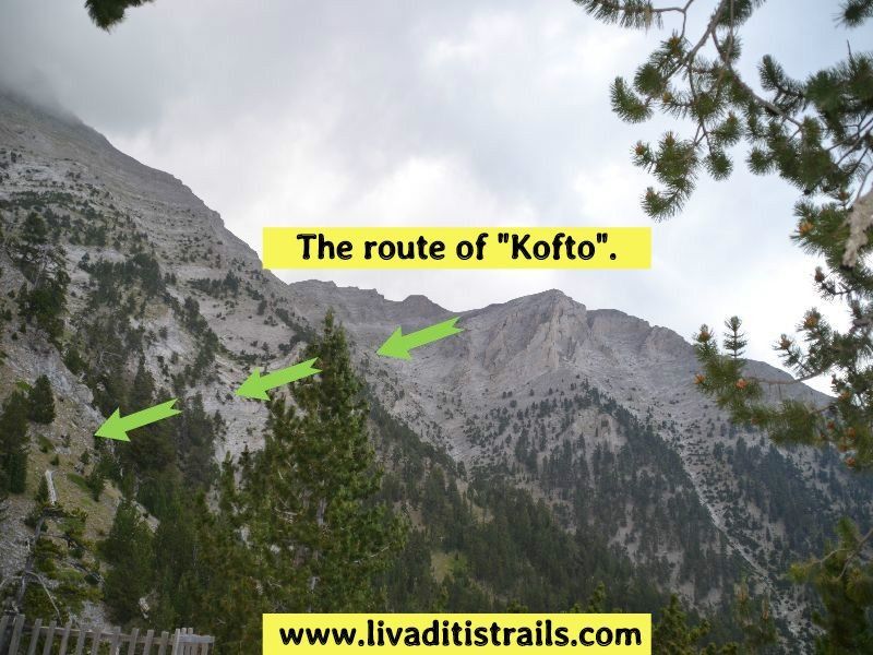
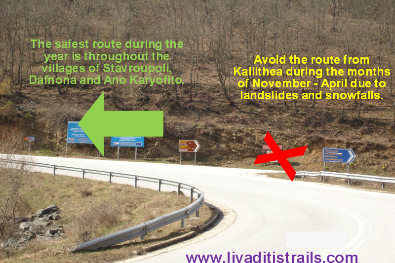
Starting from the city of Xanthi, you could follow the road to the small town of Stavroupoli and then after passing the villages of Dafnona and Ano Karyofito you end up, after a distance of 48 km in the mountain village of Livaditi at an altitude of 1.250 meters. While you are on your way to Stavroupoli and more specifically at the height of Lykodromio at an altitude of 285 meters, you will notice that there is a right junction, which ends up in the village of Livaditi through Kallithea. It is advisable to avoid this route during the months of November to April, because due to frequent snowfalls the route closes and it is difficult to get to your destination (this road is of minor importance and during the winter season snow removal equipment is not available). Also, there is no telephone signal all the way, just on a few points. This particular route is far more pleasant to be followed during the other months, from May to October (Picture 1)...
 Picture 1.
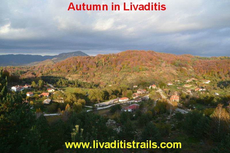
Livaditis is the highest mountain village of Xanthi with only 8 residents (Picture 2)...
 Picture 2.
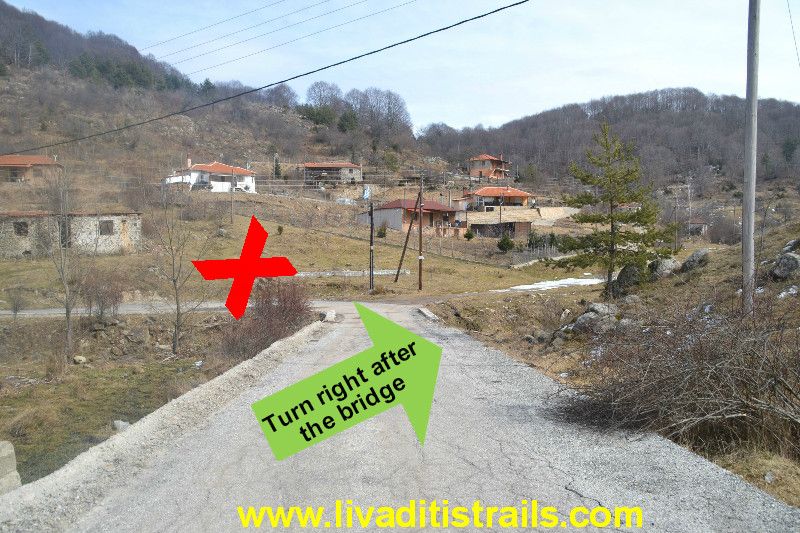
You will start from the Mountaineering Club office (1.250 altitude) in Livaditi (it used to be the old police guarding place). You will descend to the church (The Ascension of the Lord) and as soon as you pass by, you will see a small bridge (after 410 meters of walking for 7 minutes at an altitude of 1.210 m). After passing the bridge, the road continues left, but there is a concrete road on your right hand, which you then follow (Picture 3)...
 Picture 3.
After 140 meters (3 minutes), you will come across a walnut (tree) at an altitude of 1.220 meters on your right hand from where the path begins (Picture 4)...
 Picture 4.
In the beginning, you will pass a creek, which runs through the village and is usually swollen after heavy rainfalls, and then you climb the slope in front of you. There are making tapes throughout the course of the trail, which you follow for about 600 meters (17 minutes), when you meet a rural road at an altitude of 1.275 meters, which you have to cross, so as to get on the other side and find your path (Picture 5)...
 Picture 5.
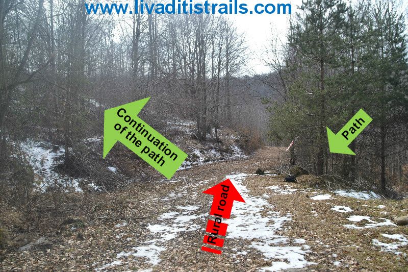
After 15 minutes and once you have walked other 850 meters, the path ends and intersects with a rural road at an altitude of 1.345 meters, where you have to turn right, to continue to your destination (Picture 6)...
 Picture 6.
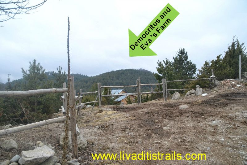
While you 're on the dirt road and after a 5-minute walking of 350 meters, you will see on your left the farm of Democritus and Eva at an altitude of 1.355 meters. They are a couple which renounced civilization and all the goods offered by it and decided to become one with nature and live the way our ancestors lived, when there were no amenities of electricity and oil heating. Apart from that , the couple is engaged with organic farming and the production of jams, while rearing horses as well. Little attention should be given to the dogs that live in the farm as they might scare you with their barking but they will not attack you (Picture 7)...
 Picture 7.
Once you decide whether you are going to visit or not the farm (we propose to do it on your return), continue on the dirt road for another 350 meters (5 minutes walking), when you meet a wooden sign and a small road on your left and onwards at an altitude of 1.380 meters. Follow the path, which after 50 meters, takes you to a larger road (Picture 8)...
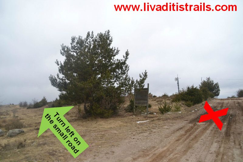 Picture 8.
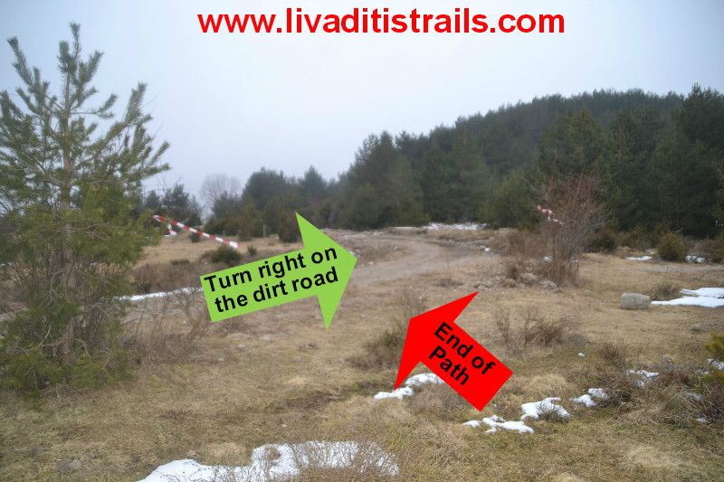
Follow the largest rural road for about 10 minutes covering another 400 meters. Towards the end, you will have on your right a field with fencing, after which a new small road starts on your left, which you have to follow. You are at an altitude of 1.370 meters (Picture 9)...
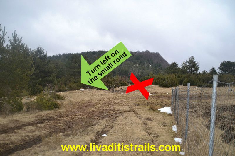 Picture 9.
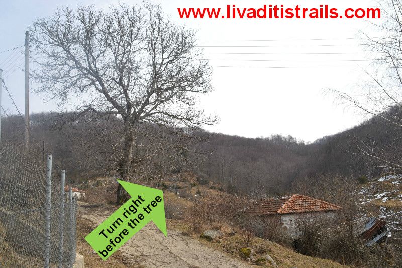
Follow this small road - a 900 meters path for about 17 minutes - when you reach a large tree, which is a sign that the final ascent to the top begins. Yoy are at an altitude of 1.355 meters and after passing the tree you should turn right (Picture 10)...
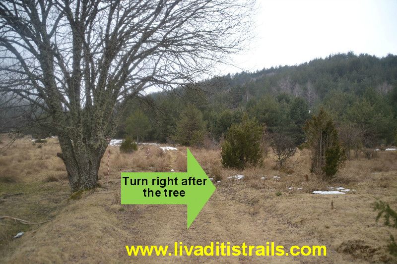 Picture 10.
There are red pads all the way which will show you the way up the cliffs. You will walk another 500 meters in 11 minutes and you will arrive at an altitude of 1.410 meters. At that point, you will see that there are stones which you should climb up so as to continue your journey to the top (Picture 11)...
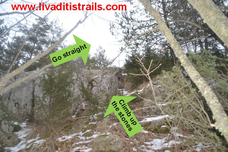 Picture 11.
Once you climb the rocks, you will walk on them (it is easy, believe us) and you will follow the marking tapes, which will lead you to the top after about 10 minutes and after walking another 200 meters (Picture 12)...
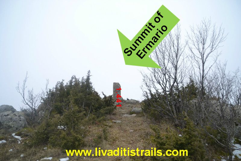 Picture 12.
When you reach the summit either summer or winter, you need to have your camera anyway. What you will witness will be unique. All the Rhodope Mountains are on your feet. The endless tops of Xanthi, Drama, Greece and Bulgaria together create a beautiful painting that you should see at least once in your life. Fortunatelly, this landscape painting is not for sale. On your return, you can visit the farm of Democritus and Eve and if you have a meal in the traditional tavern of "Kappadoka" in Livaditi, we promise you that this day will be unforgettable.
The passage of the trail occured on Saturday 24th of February 2015, the same day we gathered all the information that was mentioned, as well as the photographs included in the narrative of the path. We consider ourselves responsible, so we would like to treat those who love Nature and hiking and enjoy learning about new places with the same responsibility. We would also like, if you cross the trail above or any other on our website, to contact us (email: This email address is being protected from spambots. You need JavaScript enabled to view it.) whether we were accurate on our description or there was a flaw that should be corrected.
Thank you for your trust and for visiting our website.