")
Length: 5 km.
Duration: 1 hour and 40 minutes.
Altitude slope: 113 meters.
Route Rating: Cross and return on the same path.
Recommended: In all mountaineering clubs of the country, families and all ages.
Season: All year round.
* The information listed above is just to go.
This path is the calmest and most-walked one in Xanthi. Definitely, all our fellow citizens, but also many of our compatriots from all over Greece, have gone for a stroll on the path. The first 3,5 kilometers of the trail are along the river, while the other kilometers are in the nature that absorbs you.
General Information:
It is a trail of total length 5 km, from which the 4 km and 100 meters are on a path, and the remaining 900 meters are performed solely at your own risk, on the train lines. Therefore, we would recommend it to people who are familiar with climbing, hiking or sports activities to follow this path on the train lines, with the sole purpose, to find the path that goes to the deserted settlement of Kromniko. In no other case we do not recommend following the lines. The duration is 1 hour and 40 minutes. The trail is not signposted but the whole route is clearly distinct. Along the path there is signal for all the phone companies. Generally, it is classified as an easy path and until you reach the train lines it can be performed by children over 6 years.
USEFUL PHONE NUMBERS:
European Emergency Number: 112
Fire Brigate: 199
E.K.A.V. (Ambulance Help): 166
Health Center of Stavroupoli: +30 25423-50000
O.S.E. (Organization of Greek Railways): +30 25410-22581
All the above are summarized in the following chart:
Click on the word "Wikiloc" so you can store the route on a Garmin gps device or Androit or Smartphone device. You can also print the information without the illustrations shown below. The tracking of the trail was done using a 650t Montana gps device by Garmin
In Particular:
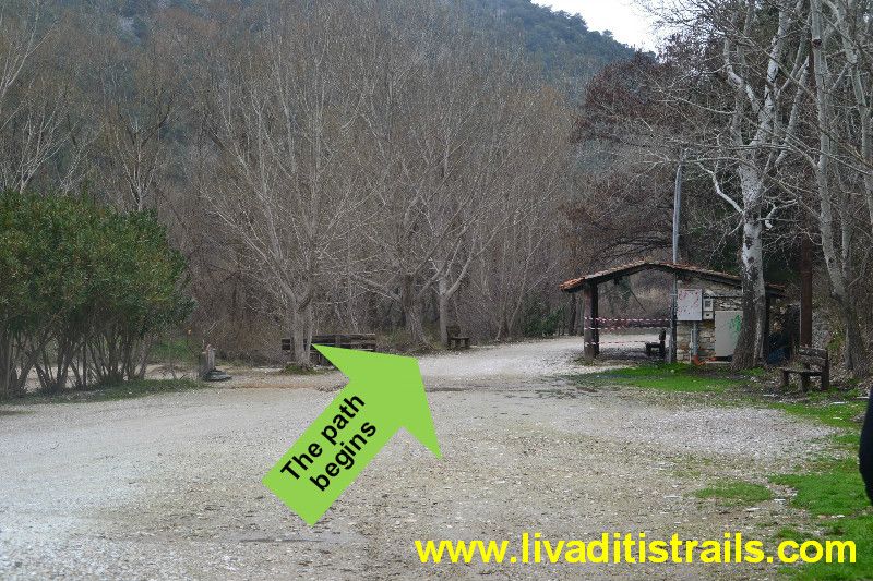
You will start from Xanthi and follow the Old National Road "Xanthi - Kavala". After 7,5 km, you will reach the petrochori village, where there are traffic lights on the junction. Follow the road on your left hand to reach the Egnatia road, while the road straight leads you to the village of Toxotes. So after the traffic lights, drive for 5,5 km until you reach a junction on your right hand (just before the bridge of the Nestos River) where you have to turn, and you instantly enter the village of Toxotes. 900 meters after the intersection and while you are in the Toxotes village, you will reach a train guarded crossing and after you have passed it, drive for another 1 km and 800 meters along the river, to get the place where you can park your car and start walking (it΄s a dead end), at an altitude of just 60 meters.
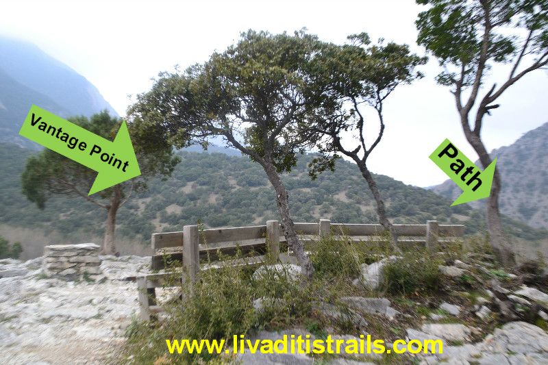
The entire route is on a stone path (the path was made by workers so as to construct the railway line and it has been maintained in a very good condition to this day). You then start walking and in about 20 minutes and once you have covered 1 kilometer and 170 meters, you reach a vantage point with benches, at an altitude of 95 meters.
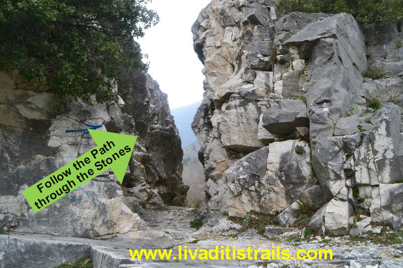
Continue walking on this beautiful stone path and once you start descending, you will get through a forest of wild hollies, which have grown up and become trees because nothing has disturbed them. Once you pass this small forest, you will go up a bit and reach some rocks (they look like the Clashing Rocks), which are very close to each other and you have to pass between them. You have already walked for another 1 km and 770 meters, in about 50 minutes at an altitude of 90 meters.
You follow the path along the river for another 600 meters having an eye contact with it and, then you start descending and you pass through a forest with large trees and branches, which are woven with each other and remind us of the ropes that Tarzan ysed to jump from one tree to another. This route will lead you directly to the railway tracks and you will have walked for another 1 km and 230 meters in about 35 minutes, covering in total 4 kn and 170 meters in about 1 hour and 45 minutes. We have reached an altitude of 75 meters.
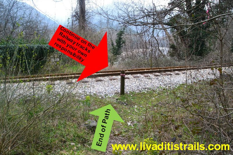
We would recommend not following the rest of the route, unless you are a climber, a nature lover or you are engaged in sports activities because you should continue on the railway tracks. So, if you want to find the path that leads to the deserted settlement of Kromniko, because that΄s your destination, you need to walk for another 510 meters and for about 10 minutes.
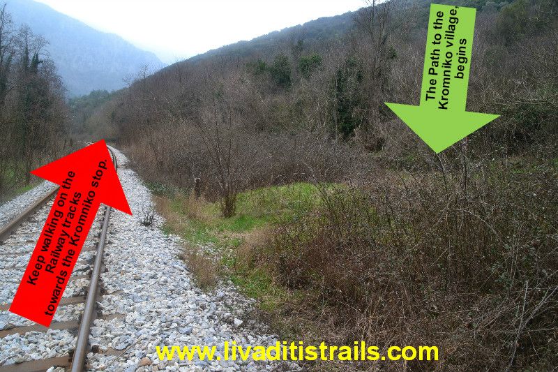
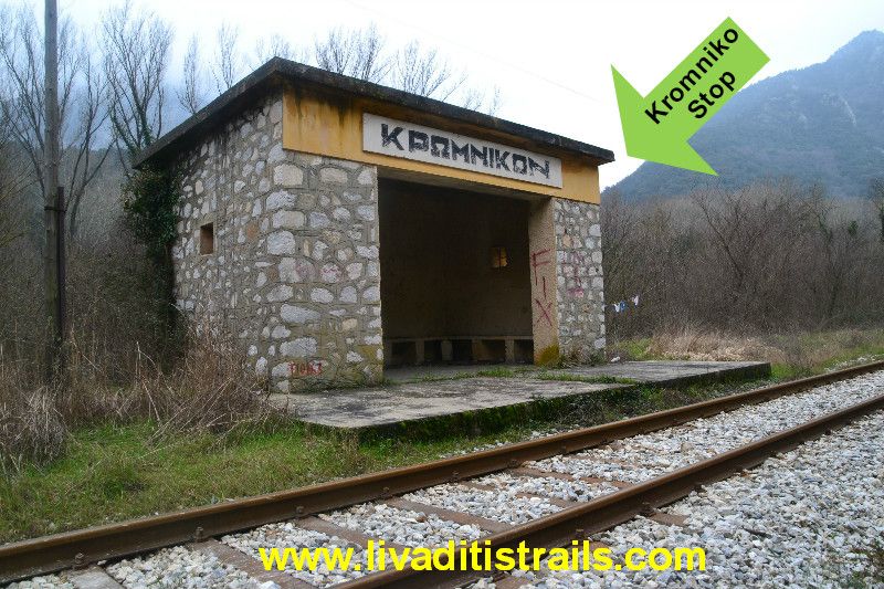
Finally, if you proceed for another 320 meters and for about 5 minutes you will reach your final destination that is the Kromniko Stop all in 1 hour and 40 minutes and having covered 5 kilometers. We would recommend, if you are determined to get to the Kromniko Stop, calling in advance OSE (Organization of the Greek railways) to find out the train timetables of that day and be more confident of crossing the railway lines.
Regarding the retur, you can walk on the same path that you followed so as to get here or there is an alternative solution; you can come into contact with one of the alternative tourism offices that organize trips descending the Nestos River and to inform you about the place where someone will wait you so as to descend the river back to Galani by kanoe - Kayak.
We believe that this combination will be unforgettable and you will be raving whenever you hear about the Nestos River.
ΧΜMmmmmmmmmmmmm we still see you on the sofa or it΄s our idea? Stand up, the river is waiting for you!!!
The passage of the trail occured on Sunday 1st of March 2015, the same day we gathered all the information that was mentioned, as well as the photographs included in the narrative of the path. We consider ourselves responsible, so we would like to treat those who love Nature and hiking and enjoy learning about new places with the same responsibility. We would also like, if you cross the trail above or any other on our website, to contact us (email: This email address is being protected from spambots. You need JavaScript enabled to view it.) whether we were accurate on our description or there was a flaw that should be corrected.
Thank you for your trust and for visiting our website.
The translation in English was made by "Fytopoulou Sofia" and we thank her, for her help.